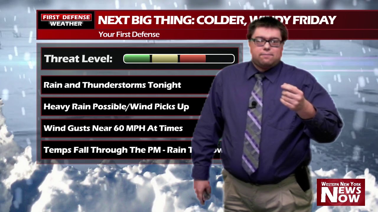
JAMESTOWN – As we’ve been hinting at for several days now, big changes are on the way to Western New York, which includes gusty winds and the return of of snowflakes.
The folks at the National Weather Service have been very busy bees issuing all kinds of watches and warnings today.
With some low-lying fog in areas in the Southern Tier, there is now a Dense Fog Advisory in place for Chautauqua, Cattaraugus and Allegany Counties until 3 PM this afternoon. Visibility could drop under a quarter of mile at times early this afternoon.

A High Wind Warning for Chautauqua County will also be going to effect at midnight and running through 5 PM Friday, along with a Wind Advisory for Cattaraugus County.

A strong wind off Lake Erie will drive wind gusts possibly up to 60 MPH, with the best chance for 60+ MPH wind gusts near the Lake Erie shoreline.
On top of all of this, the Areal Flood Watch has been reissued for all of Western New York until 7 AM Friday. With the combination of the rain and continued melting of snow and ice packs across the region, flooding might be a concern once again along local rivers and creeks.

As a system with a Warm front currently in the Midwest moves our way, rain showers will began this evening and last through the overnight. There might be some embedded thunderstorms within that cluster with heavy rainfall.

Our exclusive in-house model data is suggesting rainfall amounts over a half inch to over one inch in spots. That will not be welcomed by area waterways where are already running high from the recent snow and ice melt.

Following right behind it, will be a strong Cold front that will shift gusty 20 to 30 MPH winds out of the west/southwest. The official high temp on Friday will be near 50-degrees occurring just after Midnight, but the mercury will drop radially after the frontal passage, ending the day down into the teens by 5 PM.
Any rain leftover on Friday will switch to snow for the snow for the afternoon; we’re not expecting much accumulation out of that.
Another thing we have to keep our eyes on tonight is the potential for a flash freeze. Any standing water or moisture will turn to ice as cold air pours in behind the Cold front. That could leave us with slick spots on area roadways for the morning commute.
The weekend will be cold but mainly dry. We begin to moderate a little bit by next week as temps make it back into the lower to mid 30s.

WNYNewsNow is a proud Ambassador for the NOAA Weather-Ready Nation program.


Leave a Reply