JAMESTOWN – Today will be a rather nice day weather-wise, things will begin to go downhill overnight tonight and last through Thanksgiving day with a strong system passing close to the region.
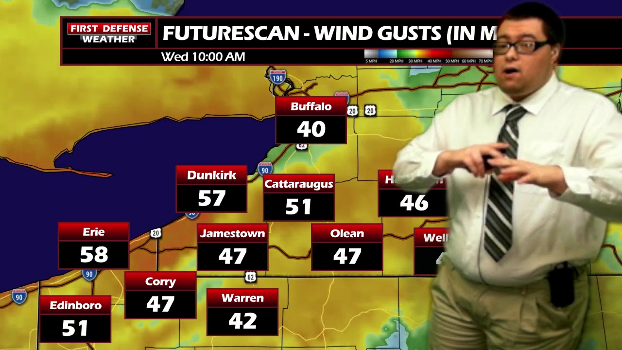
The National Weather Service in Buffalo maintains the High Wind Watch for much of Western New York, excluding Allegany County, going into effect at 7 a.m. Wednesday and running through 10 p.m. Wednesday.

The National Weather in Cleveland has issued a Windy Advisory for Erie and Crawford Counties in Northwest Pennsylvania, going into effect 10 a.m. Wednesday and running through 7 a.m. Thursday.
The Lakeshore Flood Watch also remains in effect for the Lake Erie Shoreline communities of Chautauqua County until 10 p.m. Wednesday. With the strong winds, some beach erosion and lakeshore flooding could occur from high lake water level and high wave action.

Lots of sun will take us through the afternoon with above average temperatures ranging between 47 and 59 with a southwest wind 5 to 10 MPH.
Tonight starts dry with partly to mostly cloudy skies. As a Cold front drops on through, scattered rain showers will develop overnight. Temperatures will not be budging much; only dipping off 45 to 50.
A deep storm system current throwing snow across parts of the Rockies will be making a B-line towards the Great Lakes region and pass just to the northwest of the region. While we will be on the warmer side of the system with highs near the 60-degree mark tomorrow, the projected storm track is prime for strong winds through the day on Wednesday.
Wind gusts will range between 45 and 60 MPH through the day with the strongest winds, as always, found near the Lake Erie Shoreline. Those strong winds will settle down gradually as head through the day on Thursday but will still remain breezy with gusts 30 to 40 MPH, especially early in the day.

The storm system will bring widespread rain showers to the area with some pockets of embedded thunderstorms possible. While widespread severe weather is not expected with overall atmospheric instability forecast to be rather weak, non-thunderstorm wind gusts nearing 60 MPH at times will not take much to elevate a stronger storm to severe levels with damaging winds in the afternoon.

As the storm continues to move into Ontario, colder air wraps around the departing Low, dropping temperatures and changing the rain to snow showers Wednesday night into Thursday. There could be some added lake effect off the southeastern end of Lake Erie, mainly across the higher terrain of the Southern Tier.
Snow showers will continue early in the day on Thanksgiving, slowly tapering off for the afternoon with highs in the lower 30’s.

Black Friday is looking nice with partial sunshine but below average highs in the upper 30’s.
Another chance for snow showers will come out way Saturday through early next week with temps falling below average once again to start December.
WNYNewsNow is a proud Ambassador for the NOAA Weather-Ready Nation program.
![]()


Leave a Reply