JAMESTOWN – While the widespread snow will continue to taper off this afternoon, it will quickly become lake effect throughout the night with some of the coldest air so far this season coming Wednesday through Thursday.
The National Weather Service has issued a Winter Storm Watch for Lake Effect Snow for Chautauqua County and Erie County, PA, going into effect at 1 a.m. Wednesday morning and running through 7 a.m. Thursday.

That means there is the potential for heavy lake effect snow across the area; our first Winter Storm Watch of the season.
The Weather Service has opted to cancel the Winter Weather Advisory that was in place for the Southern Tier as the widespread snow associated with the storm system has started to come to an end. It was originally set to expire at 4 p.m. Some snow flakes are still possible; through the afternoon however. Highs 28 to 34.
The lake effect machine will start to rev up tonight with more widespread snow this evening. Most of the snow early on will be lake enhanced before turning to complete lake effect by the morning hours. Accumulations could range between 1 to 4 inches. The winds are also going to come up out of the west at 15 to 25 MPH. Lows 20 to 25.
The highs tomorrow will likely occur very early in the morning as a strong Cold front plows through the region. Mornings highs 23 to 27, falling to around 11 to 16 by the afternoon. Lake effect snow will continue through day in squalls with moderate to heavy snowfall rates at times. Blowing snow could also become an issue with wind gusts up to 45 MPH.
With a healthy wind and falling temperatures, there will be a bone-chilling wind chill through the day on Wednesday. By the end of the day, most of the area will be feeling more like zero to just below zero, dropping to sub zero levels overnight as the lake snow continues. Lows 6 to 13.

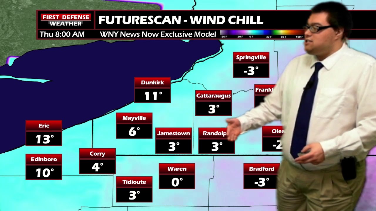
Thursday morning will be a slow go early on before the lake squalls start to fade away. Wind chills also remains just below zero to just above zero for the morning drive. Temperatures will not respond very much; staying into e upper teens to around 20 through the day. At least the winds will start to die down through the day.
When we’re all set and done, spots in the hillier terrain could resolve close to 10 inches by Thursday afternoon with 6 to 8 inches elsewhere and 4-7 inches eastward with most of that falling Tuesday night into Wednesday.

High pressure returns to the region through the end of the week and provide several days of mainly dry weather with slightly above average temperatures into early next week.

The chances of a white Christmas, as it stands right now, is going to rely on how much snow we pick up from this upcoming lake effect event. We are hopeful that if we receive the amounts were are expecting at this time, there should be enough snow on the ground to allow for melting over the weekend while still keeping snow on the ground for Christmas Day (NOAA officially describes a “White Christmas” as one with having at least one inch of measurable snow on the ground on Christmas morning).
WNYNewsNow is a proud Ambassador for the NOAA Weather-Ready Nation program.
![]()


Leave a Reply