JAMESTOWN – As advertised, lake snow has setup shop off the eastern end of Lake Erie and has been impacting the region through much of the day. That snow will continue this afternoon with falling temperatures and rather nasty wind chill values overnight into tomorrow morning.
The National Weather Service maintains the Lake Effect Snow Warning for Chautauqua and Cattaraugus Counties and Southern Erie County, PA until 7 a.m. tomorrow morning.

There is also a Winter Weather Advisory in place for Warren County, PA also until 7 a.m. Thursday.
High temperatures for the day have already occurred across the entire region, thanks to a strong Cold front pushing through. Jamestown’s official high was 23, which occurred at Midnight. Since then,. we have been slowly dropping through the lower 20’s.
After encountering a little bit of wind shear earlier today, the lake snow bands are back and they will continue to strengthen through the afternoon. Daytime snow accumulations will likely range from 1 to 2 inches on the lower evaluations upwards of 3 to 4 inches on the hills. Temperatures to end the day ranging from 11 on the hills to near 20 at the lakeshore. With a healthy west wind up to 30 MPH at times, blowing snow could become an issue within the lake bands.

Lake snow will continue tonight, picking up an additional 4 to 7 inches on the hills, 2 to 5 elsewhere, and blowing snow will still be a factor with winds 15 to 30 MPH. Gusts could be near 35 MPH at times.
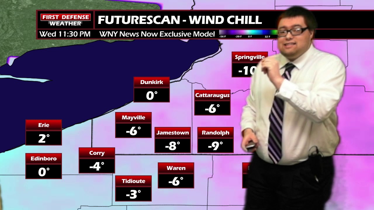
Wind chill values will likely drop sub zero tonight and will last through the overnight hours into early Thursday morning when combined with he wind and cold air temperatures.

While the wind chills will be quite bitter, these forecast values do not warrant the issuance of a Wind Chill Advisory by the National Weather Service. The criteria for a Wind Chill Advisory varies greatly from one NWS office to another but Buffalo’s criteria states wind chills of “at least” 15 degrees below zero must be forecast to warrant an Advisory issuance.
While not to Advisory level, male no mistake about it, it is going to be downright cold through the overnight. Mornings lows will likely drop between 6 to 12, leading to very cold start to the day on Thursday.
The lake effect to start to cutout through the morning hours with maybe a few more light lake snow showers or flakes for the afternoon. Highs only ranging 16 to 22 but at least the winds will subside a bit to 7 -14 MPH so it won’t quite as harsh for the afternoon.
High pressure returns Friday with a change in the upper air pattern aloft allowing for a “warmup” to occur by the weekend into early next week. The chance for a white Christmas is riding on this on going lake event event. We are banking on that if we receive the additional snowfall accumulations we’re expecting, there could be enough snow on the ground to withstand the melting that will occur over the weekend.

However, there are absolutely no guarantees on this as we are still not feeling confidant enough at this time that we can retain enough of the snowpack. A “White Christmas” is officially defined by NOAA as having at least one inch of measurable snow on the ground on Christmas morning.
WNYNewsNow is a proud Ambassador for the NOAA Weather-Ready Nation program.
![]()


Leave a Reply