JAMESTOWN – After a quiet day today, Lake Erie will get excited and generate squalls of lake effect snow through the day tomorrow. Beyond that, a very complex and complicated storm system will be arriving for the weekend with lots of questions remaining in regards to who sees what and of how much.
The National Weather Service has issued a Winter Weather Advisory for Lake Effect Snow, going into effect at 10 p.m. this evening and running through 6 p.m. Wednesday afternoon for Chautauqua and Cattaraugus Counties in the Southern Tier, expiring at 1 p.m. Wednesday for Southern Erie County, PA.

For this afternoon, quite simple and quiet. Mostly cloudy with a light wind. Highs 31 to 40.
As a front sweeps through the region, bands of lake effect snow will set up off the eastern end of Lake Erie tonight as the winds shift more west-southwest directly over the warmer lake water. By morning, some spots in the hills could receive up to 2 or 3 inches with 1 to 2 elsewhere. Morning lows 21 to 28.
Lake snow squalls continue into Wednesday, pilling up an additional 2 to 4 inches with some localized amounts up to 5 inches, before tapering off later in the day. The winds will also come up with that snow, gusting to near 40 MPH at times creating limited blowing snow. Highs 23 to 28.
When we’re set and done by Wednesday evening, the hillier terrain could receive up to 5 to 6 inches with localized totals nearing 7 inches, 3 to 4 along the lower elevations, 1 to 3 elsewhere.
After this, our attention will then turn to yet another storm that will impact the region Friday through Sunday. A front will stall out across Western New York and bring several waves of Low pressure through the region.
The first wave will bring widespread rain showers to the area on Friday with warm and moist air drawn in from the Gulf of Mexico. That should help spike our temperatures close to 50 once again.
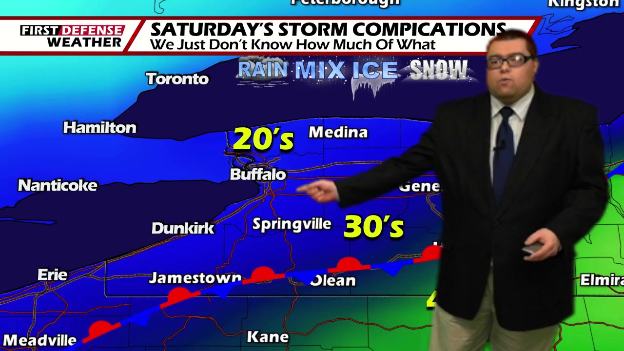
The big debate will be the weekend. As it stands now, the stalled front will shift a bit to the south on Saturday and drag much colder air into Western New York. With that being the case, highs will occur very early in the day, dropping to near or around 30 by the end of the day.

What still needs to be figured out is the exact timing of which that front will propagate southward and where the temps will fall to. That plays a vital roll in what type of precipitation will fall. Based on current guidance, we will likely pick up about an inch or two of liquid but what that will fall as is anybody’s guess at this point.

If we can maintain enough warmer air, it will be a cold heavy rain that could pose a flooding problem. If the air is colder, then the idea of a wintry mix with significant amounts of icing possible will be on the table. There is also the chance we’ll turn the air much colder and change over to potentially heavy snow. Using a 10:1 water to snow ratio, with 1 to 2 inches of liquid, that would equate out to possibly a foot or more of area-wide snow.

There are many questions that we simply just cannot answer at this time. We will have a better idea has we get within a few days of the event. Just understand that the weekend has the potential for high impacts and close monitoring will need to be kept throughout the week.
WNYNewsNow is a proud Ambassador for the NOAA Weather-Ready Nation program.
![]()


Leave a Reply