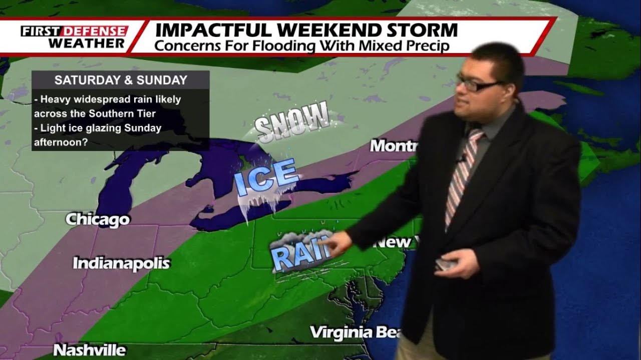
JAMESTOWN – While this afternoon will be rather nice and quiet, a deep storm system is making its move towards the region and could have some big impacts over the weekend in regards to heavy rainfall. There remains some questions for Sunday given how colder air will ride close the area.
Today will be a nice day overall with partly sunny skies. Highs will range 30 to 37 with a south wind around 10 MPH.
Tonight starts dry but rain showers will develop overnight as the first hints of our next storm system begin to impact the region. Lows will also occur early tonight. 28 to 34, rising through the nighttime hours as a Warm front pushes in. We’ll likely start the day around 37 to 44 as temps continue to climb. The wind will start to pick up once again with gusts possibly near 40 MPH.
Those showers will then turn into a widespread soaking rain through the day Friday. There will likely be some pockets of moderate to heavy rain at times with highs close to 50 degrees across much of the region, It will also remain windy with gusts possible up to 40 MPH or a little stronger.
Widespread rain and gusty winds will continue Friday night with pockets of moderate to heavy rain. Temperatures not budging much; only dipping back into the mid 40’s before another front moves in and rises temps into the lower 50’s by morning.
It is Saturday when we will start to see the influx of more heavier rain into the region with again, the rain being widespread in nature. Temps will soar into the upper 50’s with some spots near the Lake Erie shoreline maybe topping 60 degrees. The wind will also stay up through the day as well with gusts over 30 MPH.
In regards to rain accumulation, down below is a snapshot of FutureScan using our in-house computer model going through early Saturday morning. The in-house model is likely over-estimating some of these totals but it does give us a good idea in regards to what we’re going to dealing with through the weekend.

As we see it right now, we’ll likely pick up around an inch of rain Friday and Friday night, possibly another inch to inch and a half on Saturday and Saturday night and when combined with ice and snow melt, all of that water is going to add up and at some point, we’re going to spring a leak. Area-wide flooding is a great concern both Friday and Saturday with all of this excess moisture pushing in. While no official word is out yet from the National Weather Service, we would not be shocked if we see some sort of Flood Watch issued for the weekend.
Then, we shift into Sunday. The day will start with rain but will transition over to maybe some sleet and freezing rain in the afternoon as colder air is allowed sink further southward into the region. Given how close we will be to a stalled frontal boundary, the amount of cold air that seeps down is a bit questionable at this time. If we have enough colder air to work with, we may change over to some show showers for a period late in the day before the precipitation cuts out for Sunday night.

We’ll sneak in a dry day on Monday before we reintroduce the chance for a few rain and snow showers on Tuesday with temperatures remain above average in the lower to mid 40’s through the middle of next week.

WNYNewsNow is a proud Ambassador for the NOAA Weather-Ready Nation program.
![]()


Leave a Reply