JAMESTOWN – We’re finishing up the day on a strong note with a good amount of sunshine and above average temperatures. However, old man winter has not forgotten what season we are in and he will be making a return in a drastic way over the next several days.
The National Weather Service has posted a Winter Weather Advisory for Lake Effect Snow, going into effect at 1 a.m. tonight and running through 6 p.m. Thursday evening for Chautauqua and Cattaraugus Counties.

Precipitation will return to the region overnight, first starting out as rain showers before transiting over to lake effect squalls by the morning. Most areas should pick up an inch or less of new snow. The wind will also tick up overnight as well with gusts possibly reaching 40 MPH at times. Morning lows 27 to 34.
Lake snow becomes better organized through the morning with an uptick in snowfall intensity. While it will not be snowing everywhere at any given point due to the localized nature of lake effect, snowfall rates could reach up to one or two inches per hour. Early morning highs in the lower 30’s, sliding to around 21 by the end of the day.
The winds will still remain a factor tomorrow with healthy westerly wind 20 to 30 MPH with gusts up to 40 MPH. That could be just enough to cause blowing and drifting snow, reducing visibilities at times and making for hazardous travel.
In terms of forecast snow totals, we’re likely looking at 4 to 6 inches on the highest hills of the Southern Tier, 2 to 4 across the lower elevations, 1 to 3 at the immediate Lake Erie shoreline and 1 to 3 inches farther south and east.

Any leftover snow showers will cut out on Friday but temperatures will be held down into the upper teens for most. This will be a preview of what is to come down the road into next week.
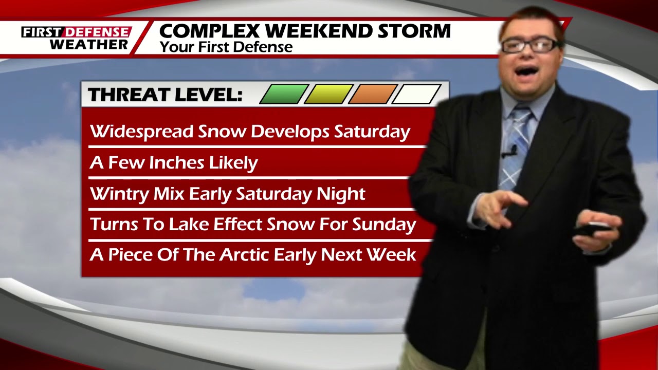
As we have been discing throughout much of this week, another storm system will move through the Great Lakes region over the weekend and will once again be impacted.
While we don’t have all of the good quality high resolution model data in yet as we’re still just a little too far out, it does look like that the projected path of the center of the storm will be to our west and north. This will likely equate out to an area-wide snowfall on Saturday, picking up at least a couple inches.

Heading into Saturday night, temperatures will be hovering around the freezing point, allowing for a limited window of wintry precipitation of rain and sleet. We won’t completely rule out a brief period of freezing rain but that potential is rather small, given the current setup.
The wintry mix will then turn into lake effect snow for the day on Sunday with some guidance suggesting it could be heavy lake snow at that. Remember that we’re still out of range with the quality data so Sunday’s forecast could entirely change between now and then, but the consistency and overall good agreeability with the longer range data, heavy lake effect snow is entirely possible.
Given the current projected track, this will be prime for strong winds on Sunday as well. Wind gusts could possibly reach up to 50 MPH through the day.
At this stage in the game, we’re still not confident enough to throw out a range of numbers for the weekend, especially for Sunday. We will know much more tomorrow at which point, we likely should have a preliminary idea on snowfall.
Beyond the weekend, it will just get plain-out cold around here for next week. Both Monday and Tuesday, highs will be in the mid to upper teens with single digit lows.

Looking even further down the road, it appears that the colder pattern will continue throughout much of next week.
WNYNewsNow is a proud Ambassador for the NOAA Weather-Ready Nation program.
![]()


Leave a Reply