App users, tap here to watch video
JAMESTOWN – Mother Nature will be giving us a taste of July-like air come Tuesday with soaring temperatures and humidity. A few thunderstorms will be likely on Wednesday with some of them potentially being on the punchier side in the afternoon.
What a fantastic way to start off other week. We had lots of sunshine today with very low humidity and seasonable temperatures. Tonight will be another good looking weather night. Mainly clear, starlit skies and a light wind overnight. Lows 56 in the valleys, 64 at the Lake Erie shoreline.
As we shove a Warm front through the region early tomorrow, temperatures will skyrocket through the day along with the humidity as an influx of moisture is carried in with that frontal passage. Highs will range 83 at the waterfront to 90 or a little above inland.

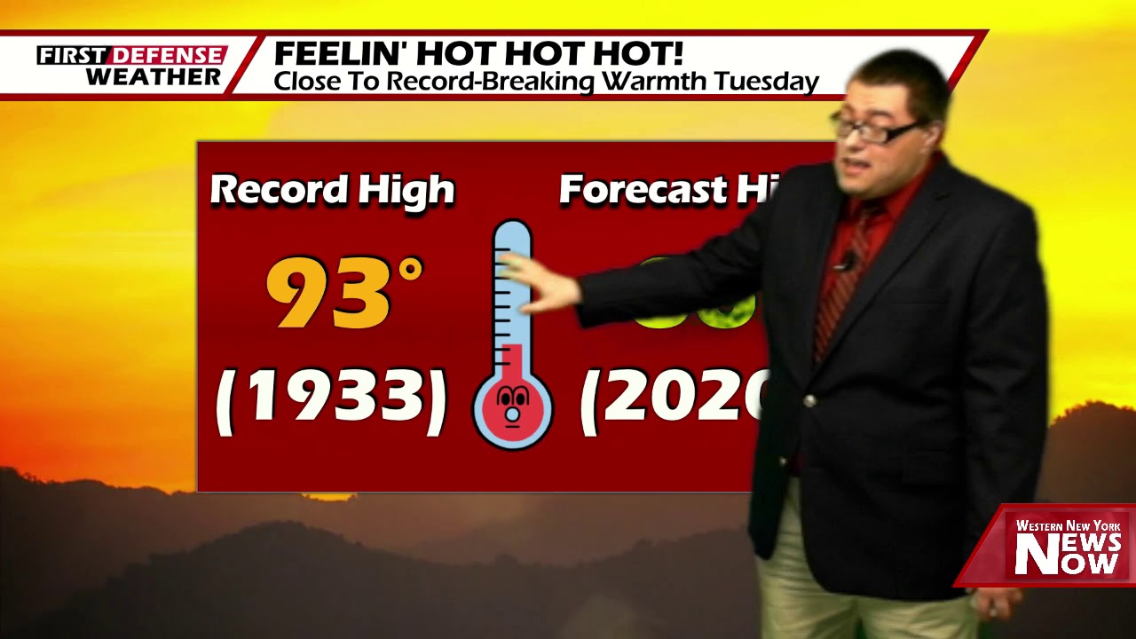
While we’re not expecting to break a record high in Jamestown, we’re going to come close in spots. The record high for June 9 is 93, set back in 1933.
Like we say every year, forecasting 90 in the city is very hard as it doesn’t happen very often. Even though a few pieces of data brings 90 into the city tomorrow, we’re holding our high down to 86 based on past events and the history of 90-degree occurrences.
The remnants of Tropical Depression Cristobal will move north into the upper Great Lakes on Wednesday bringing some tropical moisture to portions of the Ohio River Valley. While the majority of the moisture will remain off to our west, a strong Cold front will be prowling on our backdoor and sweep through in the afternoon.
The NOAA Storm Prediction Center has placed all of Western New York and Northwestern Pennsylvania under a standard Slight risk, a level 2 out of 5, for Wednesday afternoon.

As thunderstorms fire out ahead of that front, some of them could be strong to severe with damaging wind gusts, large hail, and heavy rain. There is a SMALL threat for an isolated tornado as well.
While overall timing still needs a little adjustment, these storms will likely enter the western most areas by around 3 p.m. Wednesday afternoon and be eastward of the region by 6 p.m. based on the current data.

Behind the passage of the Cold front, the temperatures drop back into the 70’s for Thursday with lower humidity with a chance for a couple leftover showers.
We become much cooler by Friday and into the weekend with partly to mostly sunny skies and highs in the upper 60’s to lower 70’s.
WNYNewsNow is a proud Ambassador for the NOAA Weather-Ready Nation program.
![]()


Leave a Reply