JAMESTOWN – As the widespread snow comes to an end later this afternoon, Lake Erie will generate some snow of its own tonight leading to some good accumulation amounts Friday morning. Even colder air arrives next week leading to the coldest weather we’ve seen so far this season.
The National Weather Service has issued a Winter Weather Advisory for Lake Effect Snow for Chautauqua County, going into effect 4 p.m. this afternoon and running through 10 a.m. Friday morning.

There is also a Winter Weather Advisory for Lake Effect Snow in effect for Erie and Crawford Counties in Northwestern Pennsylvania, effective 4 p.m. this afternoon until 4 p.m. Friday.

Rain has transited to snow early this afternoon as colder air has started to filter into the region behind a Cold front moving through the region. Highs have already occurred today and temperatures will continue to gradually fall through the day. Most of us will likely end the day in the upper 20’s to lower 30’s.
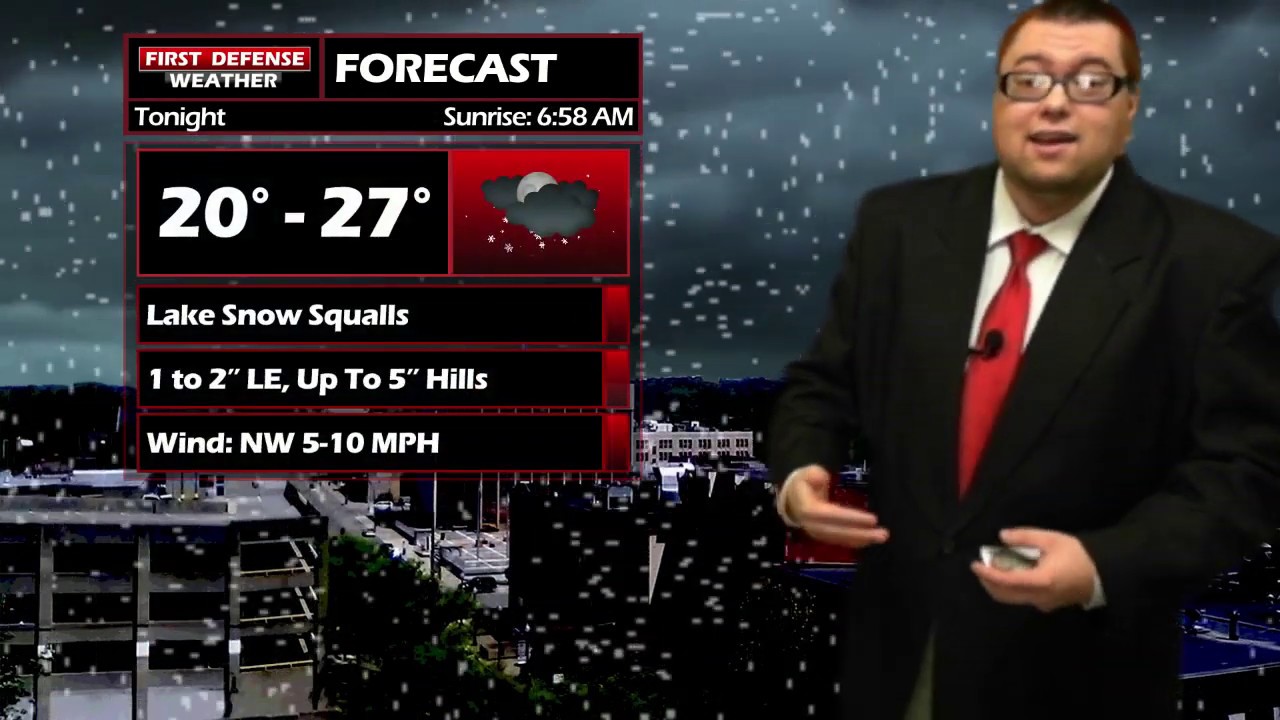
As the winds shift northwest behind the front, that colder air will excite the warmer waters of Lake Erie and generate some lake effect squalls later this afternoon through tonight. Lows will range 20 to 27.
The bands will tend to focus mainly across the higher terrain of the region where a good 4 to 6 inches could piles up, but some light accumulations of 1 to 3 inches are likely even across the lower elevations.

Any lake snow cuts out by the afternoon hours on Friday with mostly cloudy to party sunny skies for the afternoon. Highs 27 to 34.
A couple snow flakes are possible on Saturday, otherwise partly sunny. Highs in the mid 30’s.
While Sunday will be “warmer” with highs in the mid 40’s, some rain and snow showers are likely through the day but some partial sunshine is also possible.
The upper air pattern aloft will shift to favor much colder air with a deep trough coming into the eastern half of the country next week. The current long-range temperature forecast from NOAA Climate Prediction Center shows an “above 90% chance” for seeing below-average temperatures through mid November.

We could be close to breaking record low maximum highs early next week with highs struggling to make it past the upper 20’s both Tuesday and Wednesday.
The snow chances through mid next week will depend on the track of another storm system. Some early indications suggest widespread accumulating snow Monday and Tuesday but it is still too early to know exact details in terms of potential accumulations and impacts.

WNYNewsNow is a proud Ambassador for the NOAA Weather-Ready Nation program.
![]()


Leave a Reply