JAMESTOWN – After a rather quiet day today, a storm system moving close to the region will produce another chance for accumulating snow with some of the coldest air so far of the season following right behind it for later this week.
The National Weather Service has issued a Winter Weather Advisory for the entire Southern Tier, going into effect at 11 p.m. this evening and running through 4 p.m. Tuesday.

There is also a Winter Weather Advisory up for Warren County, PA, effective 8 p.m. this evening through 11 a.m. Tuesday.
This afternoon will be quiet with a mix of clouds and sunshine. For the most part, we’ll call today partly sunny. Highs 30 to 36 with a light and variable wind.
A storm system moving up the northeast will begin to impact the region overnight tonight. The precipitation may start out as rain before making a changeover to all snow overnight. Nighttime accumulations will likely range from about an inch or two across the lower elevations to 4 inches on the hillier terrain. Lows 23 to 28.
Widespread snow will continue through the day on Tuesday, tapering off later the in the afternoon. Additional daytime accumulation will range to another inch or two to 3 inches on the hills. Highs 29 to 35.
Overall snow totals during this event could range up to 7 inches in spots with the greatest totals along the hillier terrain of the Southern Tier.

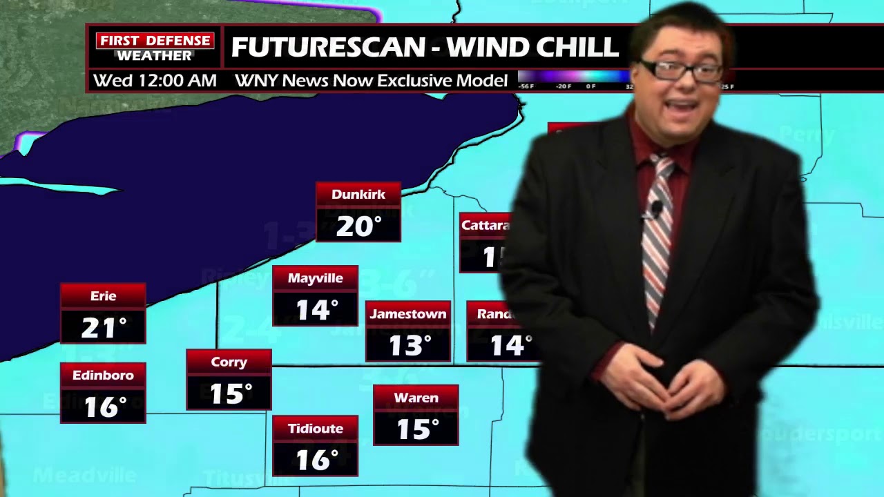
An approaching Cold front will likely trigger off another chance for some lake effect snow showers off the eastern end of Lake Erie Tuesday night into Wednesday. As the front sweeps through, the highs of 22 to 27 will occur early in the day. Temps will slip back through the afternoon, likely ending the day around 14 to 19.
The winds will also come up as well. Average winds will range 15 to 25 MPH with some gusts up to 45 MPH. With temperatures becoming that cold, it will not take very much to produce a wind chill factor. As the temperatures drop, wind chill will likely fall into the single digits.

The wind will stay up through the night on Wednesday, continuing to produce a bitter wind chill that will likely drop below zero with lake snow squalls. Actual morning low temps 6 to 12.
Thursday will start quite frigid with lake squalls continuing. Highs in the lower 20’s.
We’ll see High pressure making a return to the region by the end of the week with partly sunny skies Friday through Sunday with highs average the averages for this time of the year in the lower to mid 30’s.

WNYNewsNow is a proud Ambassador for the NOAA Weather-Ready Nation program.
![]()


Leave a Reply