App users, tap here to watch video.
JAMESTOWN – The weather will be getting active once again as we head through the reminder of the week as a deep storm system moves close to the region with widespread showers and thunderstorms and strong winds.
The National Weather Service has issued a High Wind Watch for Chautauqua County, effective 6 a.m. until 6 p.m Friday. Wind gusts could reach or exceed 60 MPH at times.

Through the afternoon today, the clouds will thicken up from west to east however, we will be mainly dry. There will be the chance for a scattered shower or two near sunset. Highs 45 on the hills to 52 near the Lake Erie shoreline.
Developing early showers will become more widespread through the overnight tonight and becoming breezy as well. Wind gusts could be near 30 MPH. It will remain rather mild; lows 40 valleys, 44 lakeshore.
The better chance for rain will be in the morning hours on Thursday with some partial clearing in the afternoon and quite mild. Overall, not a bad way to ring in the first official day of Spring. Highs 60 to 66.
As a storm system passes to our northwest through Canada Thursday night, widespread rain will make a return to the region once again. It will also become windy by the morning hours on Friday as well as the winds tick up out of the south at 15 to 30 MPH with gusts near 50 MPH.
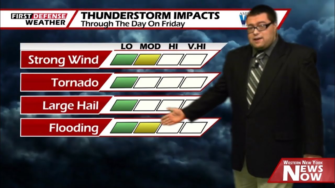
As we head into Friday, the NOAA Storm Prediction Center has outlined all of Western New York and Northwestern Pennsylvania under a low-end “Marginal” Risk (level 1/5) for severe thunderstorms through the day.

With the winds already gusting to near 60 MPH, it will not take much for a storm to tap into those winds and elevate themselves to strong or severe levels.

Some minor street flooding is also a possibility with most high resolution model guidance suggesting rainfall amounts will range between an inch to one half inch.
As noted by the exclusive Storm Potential product within our in-house FutureScan computer model, there will be enough instability in the atmosphere through the day on Friday to fuel thunderstorm development (the darker colors indicate higher thunderstorm chances).

As a Cold front moves through later in the day, temperatures will drop with that and produce a changeover to a wintry mix of rain and snow for the overnight.
High pressure returns over the weekend with a good supply of sun each day but with a more northerly wind, we’ll stay below average.

We’ll stay in the upper 30’s to lower 40’s on Monday with a small chance for an isolated rain or snow shower. We will go back to near average on Tuesday with a few rain showers and highs in the upper 40’s.
WNYNewsNow is a proud Ambassador for the NOAA Weather-Ready Nation program.
![]()


Leave a Reply