App users, tap here to watch video.
JAMESTOWN – A deep storm system passing to our northwest will be the focal point for showers and thunderstorms to develop tonight into Friday with the potential a couple of those storms could be on the stronger side. The region drys out but becomes cooler over the weekend.
The National Weather Service in Buffalo maintains a High Wind Watch for Chautauqua County, going into effect at 6 a.m. Friday morning and running through 6 p.m. Friday evening. That means potentially strong to damaging winds are on the way.

We do expect the Weather Service to upgrade that Watch to a Warning sometime this afternoon or evening.
Clouds will hang tough through the afternoon today with overcast skies for most. There could be a few peaks of sun possible. Highs 47 near the immediate Lake Erie waterfront to 59 along the inland areas.
As the low associated with that storm system starts to track its way through the upper Great Lakes tonight, widespread rain will develop across Western New York and Northwestern Pennsylvania. There could be a couple rumbles of thunder as well.
The winds will also begin to increase out of the south at 20 to 30 MPH with gusts possibly near 50 MPH by the morning hours. Temperatures will rise overnight as a warm front moves through. Early lows 53 lakeshore, 57 inland, rising to 60 to 65 by morning.
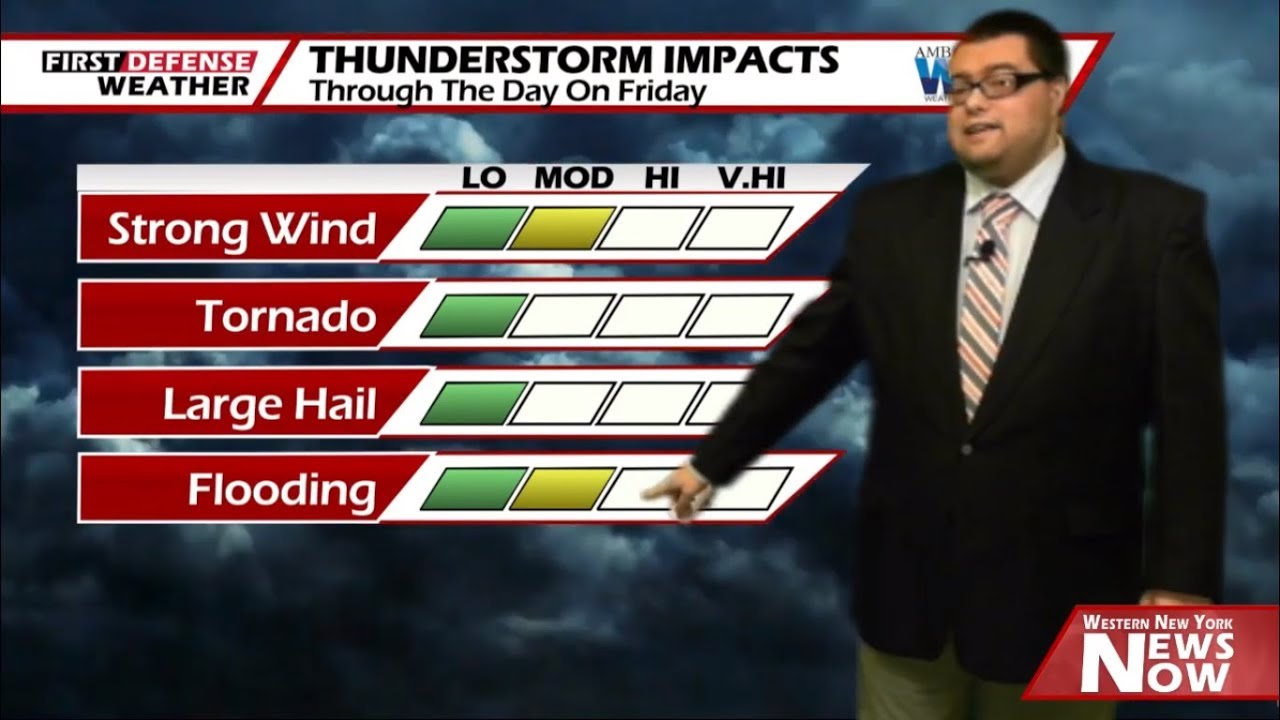
Scattered thundershowers will continue through the morning on Friday with strong winds at times. There could be a period of clearing with computer guidance suggesting some sunshine in the early afternoon. That could be enough fuel to generate another line of showers and thunderstorm by mid to late afternoon along a strong Cold front.
For that reason, the NOAA Storm Prediction Center has outlined the entire region under a low-end Marginal Risk (level 1/5) for severe thunderstorms tomorrow afternoon with primary risk factor being from strong winds.

The main timing window for the strongest storm activity looks to be from around 2 p.m. to 4 p.m. Friday afternoon. The majority of the stronger storms should be out to the east in Central New York by the drive home from work.
As that cold front plows through, temperatures will sharply drop in the afternoon. We’ll likely end the day in the upper 30’s to lower 40’s after that very mild start.
There will be the chance for a few rain and snow showers early Friday night as the system finally moves away from the region with high pressure retuning through the overnight. Lows in the mid 20’s.
While that area of high pressure will equate to a good supply of sunshine both Saturday and Sunday, the winds aloft will be favoring a northerly direction both days so that will hold down our temperatures below average.

Another trough with a potential coastal low will bring the chance for wet snow showers Sunday night and Monday before changing to a rain/snow mix or to all rain for the afternoon as temps warm into the lower 40’s.
A weak area of high pressure returns on Tuesday and makes a quick exit on Wednesday as another boundary will produce rain showers for the afternoon.
WNYNewsNow is a proud Ambassador for the NOAA Weather-Ready Nation program.
![]()


Leave a Reply